VAN KEULEN: Sea chart of the Gulf of Finland (1690)
€2.200,00
1 in stock
Johannes van Keulen (1654-1715)
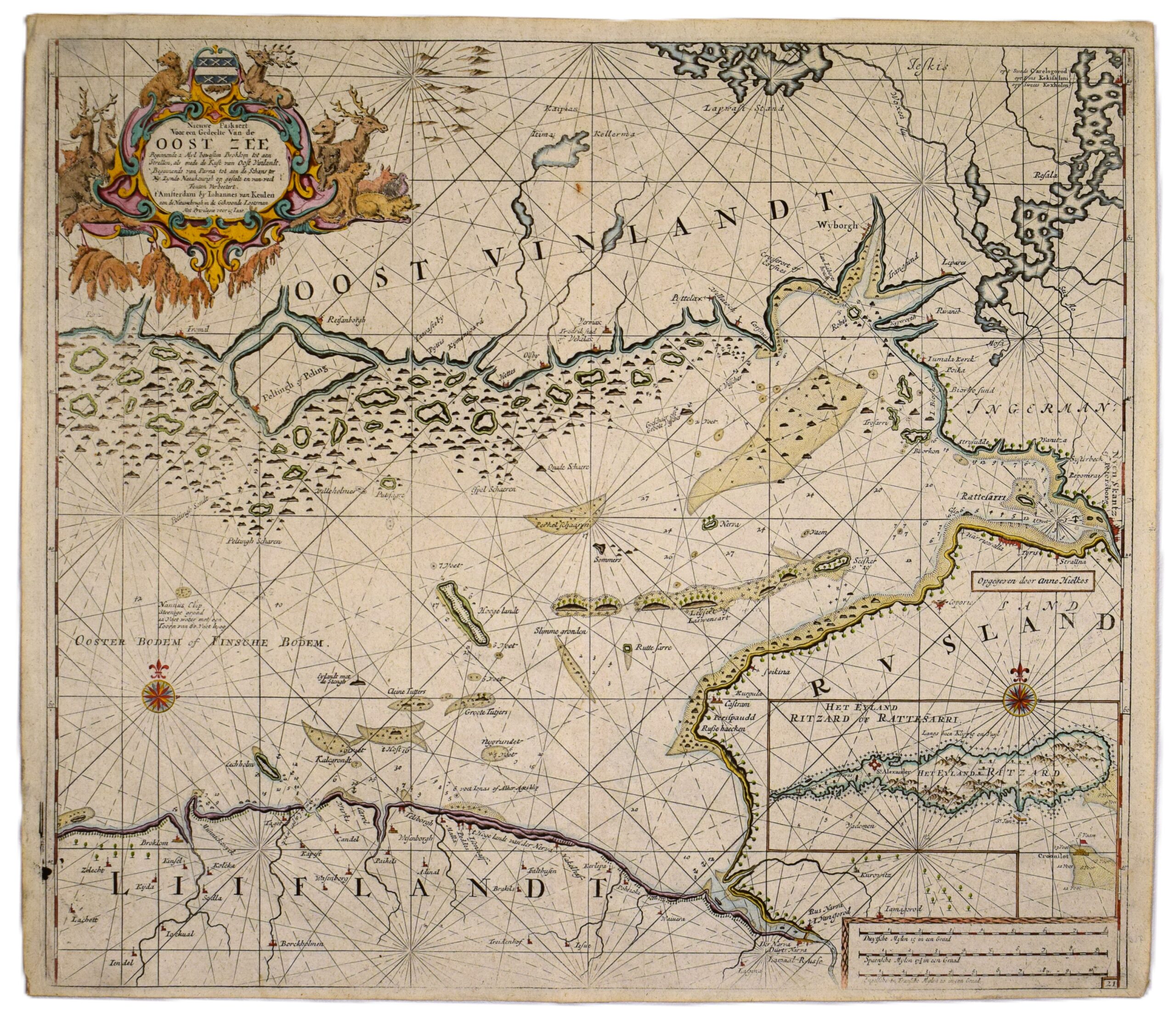
Nieuwe Paskaert Voor een Gedeelte Van de Oost Zee – Sea Chart of the Gulf of Finland – Merikortti Suomenlahden itäosasta – Sjökort över östra delen av Finska viken
An original 17th-century sea chart of the Gulf of Finland by Dutch mapmaker Johannes van Keulen. Copperplate engraving with hand-coloured outlines and decorative elements. The map depicts the eastern part of the Gulf of Finland; on the Finnish side, the Pellinki Island on the left and Viborg on the right, along with the Nyenschantz fortress – located where St. Petersburg stands today. On the Estonian coastline Wesenberg (Rakvere) can be located in the center, near Island Ekholm (Mohni).
This map features a smaller inset map of the fortress island Cronstadt; labeled on the map as ‘Het Eyland Ritzard of Rattesarri‘. The name ‘Rattesarri’ is derived from the island’s Finnish name, Retusaari.
The chart includes a large, decorative cartouche in the upper left corner, loxodromes and two compass roses. Numerous cities and landmarks detailed along the coastlines. The bottom margin shows some signs of age and wear.
- Condition: Bottom margin worn.
- Dimensions: 51 x 50 cm
Suomeksi:
Van Keulenin 1600-luvun hollantilainen merikortti Suomenlahden itäosasta. Kuparipiirros, jossa käsinväritetyt rajat ja koristeet. Kartassa on kuvattuna Suomenlahden itäosa. Suomen puolella alue Pellingistä Viipuriin, kartan oikeassa reunassa Nevanlinna nykyisen Pietarin edustalla. Viron rannikolla Narva, Rakvere ja Mohnin saari. Tässä kartassa on mukana pieni karttakuvake Kronstadtin saaresta. Koristeellinen kartushi, loksodromeja sekä kaksi kompassiruusua. Alamarginaali kulunut.
- Kunto: Alamarginaali kulunut.
- Mitat: 51 x 50 cm
På svenska:
1600-tals sjökort över Finska viken av van Keulen. Kopparstick med handkolorerade gränser och dekorationer. Kartan visar den östra delen av Finska viken; på den finländska sidan syns Pellinge till vänster och Viborg till höger, samt fästningen Nyenskans. På den estniska kusten återfinns Wesenberg (Rakvere) i mitten, nära ön Ekholm (Mohni). Innehåller en infelld karta över fästningsön Kronstadt, benämnd på kartan som ‘Ritzard’ och ‘Rattesarri’. Namnet ‘Rattesarri’ härstammar från öns finska namn, Retusaari. En stor dekorativ kartusch, två vindrosor och loksodromer. Nedre marginalen är något nött.
- Skick: Nedre marginalen är något nött.
- Mått: 51 x 50 cm.
***
Johannes van Keulen was a Dutch bookseller who founded his publishing house in 1678. He became an important publisher of marine charts, and the Van Keulen publishing house operated continuously until 1885. During the 17th century, the Dutch were beyond anyone else in producing sea charts. Through the high quality of their maps, the Van Keulen publishing house helped Amsterdam reach its zenith as a center of marine cartography.
References: Tooley’s


