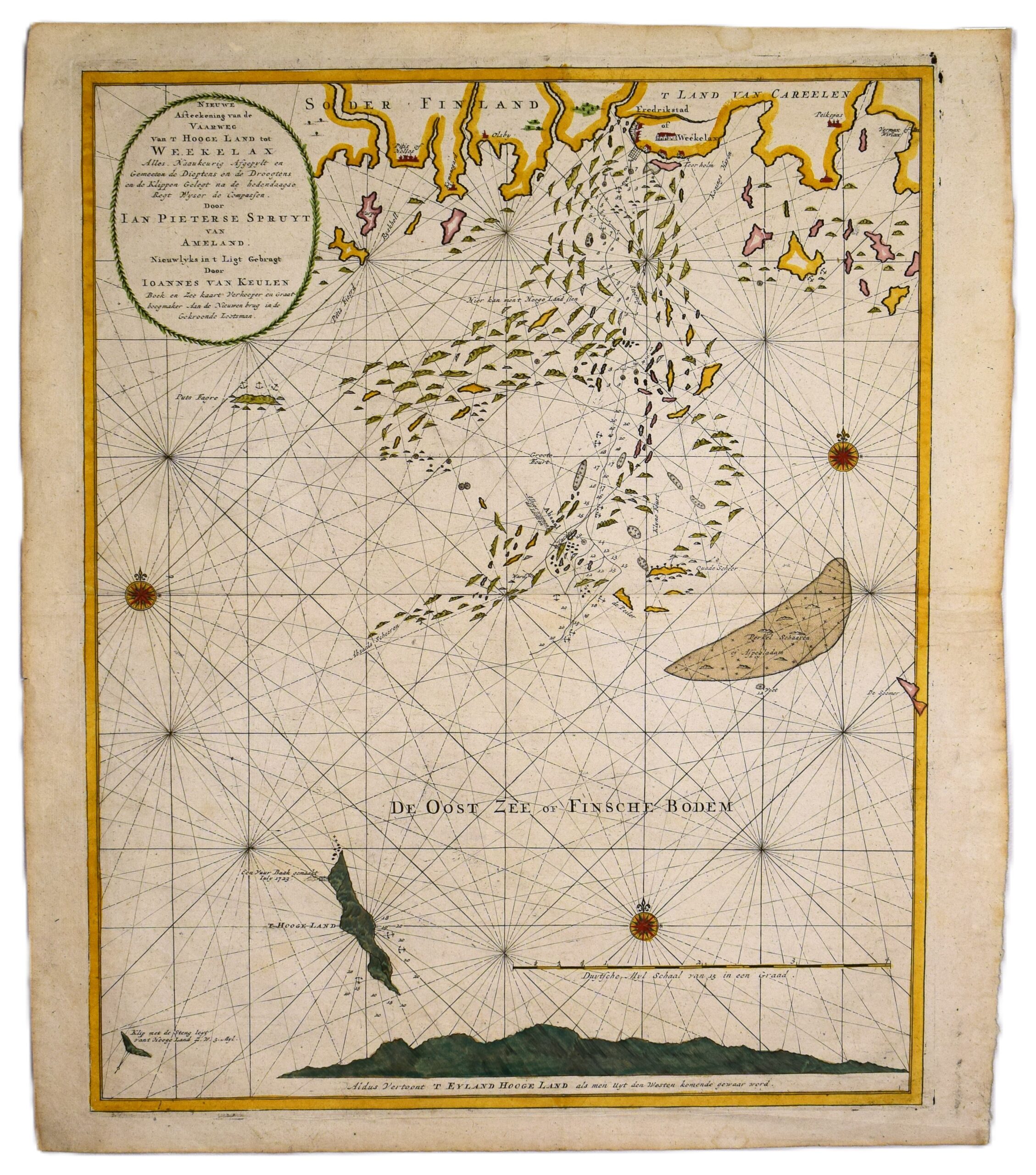
VAN KEULEN: Sea chart of Fredrikshamn and Vekelax (1720)
€3.300,00
1 in stock
Johannes van Keulen (1654-1715)
Nieuwe Afteekening van de Vaarweg Van T Hooge Land tot Weekelax
Sea chart of Fredrikshamn and Vekelax | Merikortti Haminan ja Vekelahden alueelta
| Sjökort över Fredrikshamn och Vekelax
An original Dutch sea chart of the eastern Gulf of Finland by Van Keulen. Published in Amsterdam, ca. 1720. This is a copperplate engraving with later hand-colouring. The map depicts the maritime approach to Hamina (Fredrikshamn) and Vehkalahti (Vekelax), as well as Suursaari (Hogland) and the scattered archipelago.
The title cartouche, set within leaf ornamentation, is located on the upper left corner with a scale bar in the lower right. The map features three compass roses and loxodromes. Some cities, landmarks and islands named on the map.
This map is in good condition. Wide margins and bright colours.
- Condition: Good condition.
Dimensions: 63 x 55 cm
Suomeksi:
Van Keulenin 1700-luvun alun hollantilainen merikortti Suomenlahden itäosasta. Kuparipiirros, jossa myöhempi väritys. Karttakuvassa sisääntuloväylä saariston halki Haminaan ja Vekelahdelle. Suursaari karttakuvan alareunassa. Suuri kartushi vasemmassa yläkulmassa ja janamittakaava oikeassa alakulmassa. Kolme kompassiruusua, loksodromeja. Muutama paikkakunta ja saari nimetty karttaan. Hyväkuntoinen kartta, jossa kirkas ja siisti väritys.
- Kunto: Hyvä kunto.
- Mitat: 63 x 55 cm
På svenska:
Sjökort över östra Finska viken av Van Keulen, utgivet i Amsterdam ca 1720. Ett kopparstick med senare handkolorering. Kartan visar infartsleden till Fredrikshamn och Veckelax, samt Hogland och den omgivande skärgården. En vacker titelkartusch, en skalstock samt tre kompassroser med loxodromer. Sjökortet är i gott skick med klara färger och breda marginaler.
- Skick: Gott skick.
- Mått: 63 x 55 cm.
***
Johannes van Keulen was a Dutch bookseller who founded his publishing house in 1678. He became an important publisher of marine charts, and the Van Keulen publishing house operated continuously until 1885. During the 17th century, the Dutch were beyond anyone else in producing sea charts. Through the high quality of their maps, the Van Keulen publishing house helped Amsterdam reach its zenith as a center of marine cartography.
References: Tooley’s


