Shipping
Shipping is not included in the prices. The fee will be confirmed to the customer by a separate e-mail and depends on the parcel's size and destination.
Examples: Finland 5,90€; Sweden, Germany, Baltics 8,00€; Benelux, Denmark, Spain 12,00€; Non-EU 35,00€
terms & conditions
Before ordering we kindly ask you to read our terms and conditions.
availability
The selection of our online store is not available at the bookstore. If you wish to view some items, please contact us in advance.
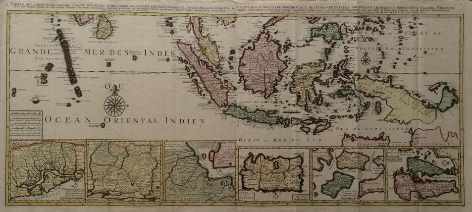
Ottens, R. & J.: Partie de la Nouvelle Grande Carte des Indes Orientales (1750)
€8.500,00
Description
R. & J. Ottens
Partie de la Nouvelle Grande Carte des Indes Orientales contenant les Isles Maldives, Ceylan, Malacca, Sumatra & Partie de la Nouvelle Grande Carte des Indes Orientales contenant les Isles de Borneo, Iava, Celebes, Mindanao, Gilolo, Molucques, la Nouvelle Guinée, la Nouvelle Bretagne & les Nouvelles Philippines
Large 18th century map of Southeast Asia. Hand-coloured copper engraving.
Two sheets combined. Interesting and detailed map with six smaller insert maps of Indonesian islands.
Dimensions 53,5 x 118,5 cm.
Additional information
Publisher:
R. & J. Ottens
YEAR OF PUBLICATION:
1750
PLACE OF PUBLICATION:
Amsterdam
Illustrations:
käsin väritetty / handkolorerade / hand coloured
Condition:
Good condition
Dimensions:
53,5 x 118,5 cm
Technique:
kuparipiirros / kopparstick / copper engraving
Other:
two sheets combined


