MOUNT & PAGE: Sea chart of the Gulf of Finland (1700s)
€420,00
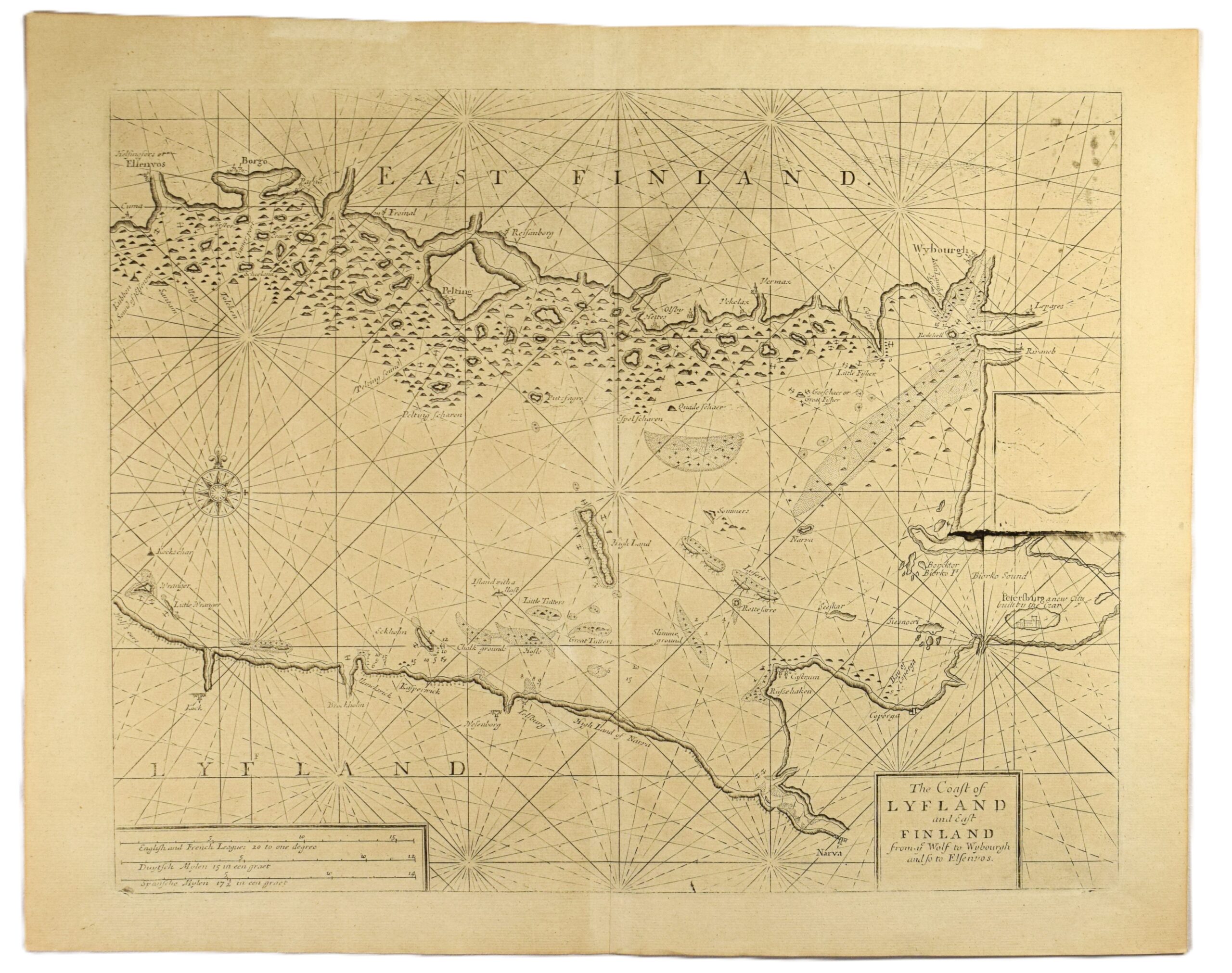
The Coast of Lyfland and East Finland from ye Wolf to Wybourgh and so to Elsenvos
Sea chart of the Eastern Gulf of Finland | Suomenlahden itäosan merikortti | Sjökort över östra delen av Finska viken
An authentic 18th century British sea chart of the eastern Gulf of Finland, published in London by the renowned firm of Mount & Page. Uncoloured copperplate engraving from The English Pilot, a maritime atlas for British merchant sailors during the 1700s.
The map covers the waters of the eastern part of the Gulf of Finland, stretching from Helsinki (Helsingfors) to Vyborg (Wybourgh) on the northern shore, and from Prangli island (Wrangler) to Narva on the Estonian coast. St. Petersburg is included in the map in the east, accompanied with the descriptive text: “Peterburg a new city built by the Czar“. The map includes an inset plan, which shows signs of heavy use. The coastline is richly detailed with coastal cities, navigational landmarks, islands and soundings. Title cartouche in the lower right corner and a scale bar on the lower left.
The map is in good condition with wide margins. The impression shows the characteristic wear of the copper plates from this era; some areas feature lighter ink where the plate had become worn from repeated use over decades.
- Condition: Good condition. Some parts feature lighter ink.
- Dimensions: 41 x 52 cm
Suomeksi:
Englantilainen merikortti Suomenlahden itäosasta 1700-luvun alkupuolelta. Värittämätön kuparipiirros. Karttakuvassa alue Helsingin ja Viipurin, sekä Tallinnan edustan ja Pietarin välillä. Pietarin kaupungin yhteydessä pieni kulunut karttakuvake sekä lyhyt kuvaus “uudesta tsaarin rakentamasta kaupungista”. Paikannimiä sekä saaria nimetty. Englanninkielinen kartushi kuvan oikeassa alalaidassa. Kartta on hyvässä kunnossa ja siinä on leveät marginaalit. Kuparilaatoille tyypillinen kuluminen näkyy painojäljessä, eikä painomuste ole yhtä vahvaa kaulttaaltaan.
- Kunto: Hyvä kunto. Kulunut kuparilaatta näkyy kevyempänä mustejälkenä.
- Mitat: 41 x 52 cm.
På svenska:
Brittiskt sjökort över östra Finska viken från första hälften av 1700-talet, utgivet i London av förlaget Mount & Page. Okolorerat kopparstick. Kartbilden täcker området mellan Helsingfors och Viborg på den finska sidan, samt Prangli och Narva på den estniska sidan. I kartan syns också det nygrundade Sankt Petersburg. Sjökortet är detaljerat med kuststäder, öar och djupsiffror. Gott skick med breda marginaler. Trycket bär tydliga spår av en väl använd kopparplåt, vilket ger en varierande svärta i linjerna.
- Skick: Gott skick. En väl använd kopparplåt.
- Mått: 41 x 52 cm
***
Mount & Page was a well-known eighteenth century maritime publisher based in London.


