Shipping
Shipping is not included in the prices. The fee will be confirmed to the customer by a separate e-mail and depends on the parcel's size and destination.
Examples: Finland 5,90€; Sweden, Germany, Baltics 8,00€; Benelux, Denmark, Spain 12,00€; Non-EU 35,00€
terms & conditions
Before ordering we kindly ask you to read our terms and conditions.
availability
The selection of our online store is not available at the bookstore. If you wish to view some items, please contact us in advance.
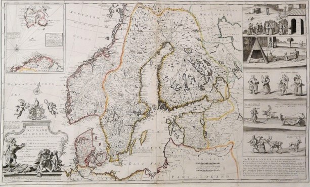
[18th century] Moll, H.: A New Map of Denmark and Sweden (1720)
€1.600,00
Description
Herman Moll (1654-1632)
A New Map of Denmark and Sweden. According to ye newest and most exact observations. By H. Moll, geographer.
18th century map of Scandinavia and the Baltics. Copperplate engraving with hand-coloured outlines.
Large decorative cartouche and a compass rose. Interesting map with placenames and administrative borders.
Large inset map depicting northernmost Scandinavia and Spitzbergen (Svalbard). Five vignettes picturing the life of Lapps. Vignette pictures are based on Johannes Schefferus book “Lapponia” published in the 17th century.
Additional information
YEAR OF PUBLICATION:
ca. 1720
Condition:
Good condition
Dimensions:
62x102
Technique:
Copper engraving
Other:
pahvikehys / passepartout


