VAN KEULEN: Sea chart of the Gulf of Bothnia (1690)
€1.400,00
1 in stock
Johannes van Keulen (1654-1715) – Claes Jansz Vooght (1638 – 1696)
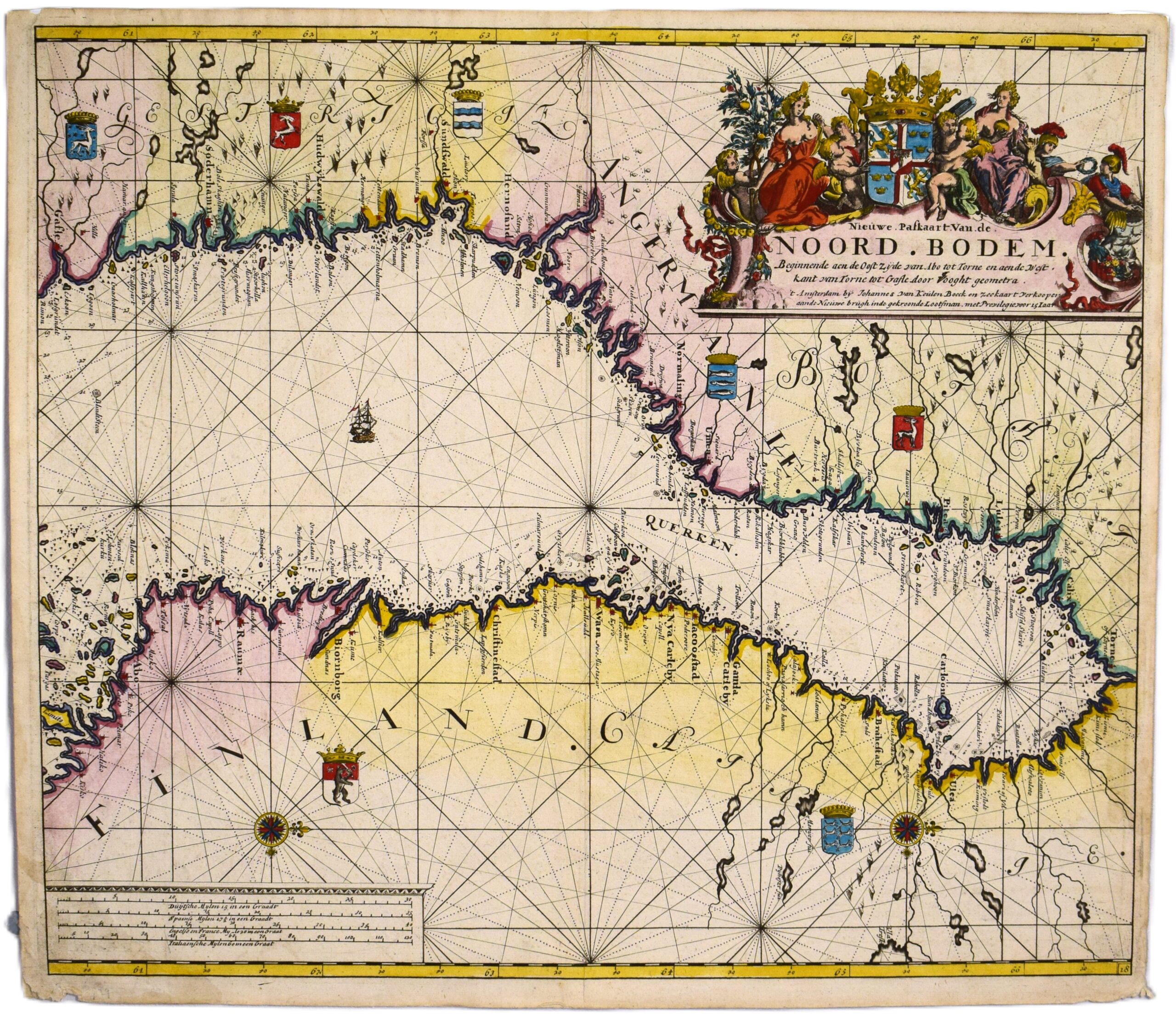
Nieuwe Paskaart Van de Noord-Bodem: beginnende aen de Oost Zijde van Abo tot Torne en aen de West-kant van Torne tot Gafle
An original 17th-century sea chart of the Gulf of Bothnia by Johannes van Keulen and Claes Jansz Vooght. This copperplate engraving features beautiful, old hand-colouring. The map is west-oriented, with Sweden at the top and Finland at the bottom. It depicts the entire Bothnian Bay; on the Finnish side Turku (Åbo) is on the far left and Tornio (Torneå) on the far right, while the Swedish coastline extends from Gävle to Torneå.
A large, decorative cartouche occupies the upper right corner. The map features seven coats of arms — five on the Swedish side and two on the Finnish — along with two compass roses and a sailing vessel. A detailed work, naming numerous cities and places along the coastlines.
- Condition: Good condition. Bright colours. Blank on verso.
- Dimensions: 51 x 59 cm
Suomeksi:
Alkuperäinen 1600-luvun Pohjanlahden merikortti. Tekijänä hollantilaiset Johannes van Keulen sekä Claes Jansz Vooght. Käsinväritetty kuparipiirros. Länteen suunnattu kartta, jossa Ruotsi ylhäällä ja Suomi alhaalla. Karttakuva ulottuu Suomen puolella Turusta Tornioon ja Ruotsin puolella Gävlestä Tornioon. Suuri koristeellinen kartushi, seitsemän vaakunaa, kaksi kompassiruusua ja yksi laiva. Yksityiskohtainen rannikko, jossa paljon paikannimiä.
- Kunto: Hyvä kunto. Kirkas väritys. Kääntöpuolella ei tekstiä.
- Mitat: 51 x 59 cm
På svenska:
1600-tals sjökort över Bottniska viken av Johannes van Keulen och Claes Jansz Vooght. Kopparstick med vacker gammal handkolorering. Kartan är västorienterad, vilket innebär att Sverige visas i den övre delen och Finland i den nedre.
Kartan täcker hela Bottenviken; på den finländska sidan sträcker den sig från Åbo till Torneå. Den svenska kustlinjen sträcker sig från Gävle upp till Torneå. En stor dekorativ kartusch, sju vapen, två kompassrosor och ett segelfartyg. En detaljerad karta med många städer och ortnamn längs kusterna.
- Skick: Gott skick. Fina färger. Kartan har blank baksida.
- Mått: 51 x 59 cm
***
Johannes van Keulen was a Dutch bookseller who founded his publishing house in 1678. He became an important publisher of marine charts, and the Van Keulen publishing house operated continuously until 1885. During the 17th century, the Dutch were beyond anyone else in producing sea charts. Through the high quality of their maps, the Van Keulen publishing house helped Amsterdam reach its zenith as a center of marine cartography.
References: Tooley’s


