Rare NJK Sailing Course Map of the Helsinki Archipelago (1886)
€800,00
1 in stock
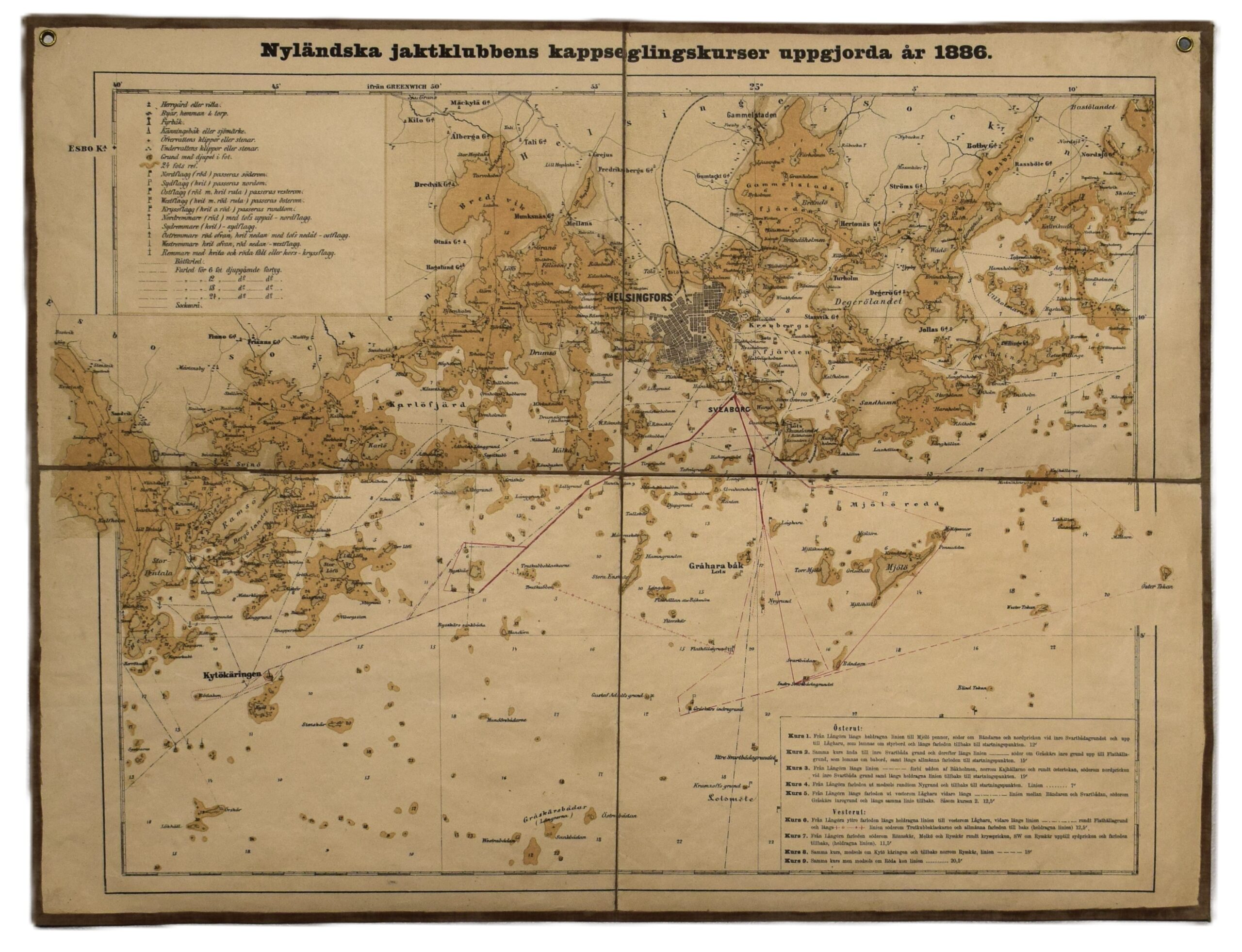
Nyländska jaktlubbens kappseglingskurser uppgjorda år 1886
A rare 19th-century sea map documenting the sailing routes of the Nyländska Jaktklubben (NJK), Finland’s oldest yacht club, as established in 1886. Three-toned lithographic print with yellow nuances.
The map features the Helsinki and Espoo archipelago, stretching from Kivenlahti (Stensvik) in the west to the island of Villinki in the east. A detailed legend in the upper left corner providing essential explanations for the various sailing route markers and navigational signs used during late 19th-century. A list of all the route alternatives is situated in the lower right corner. All texts are in Swedish.
As an authentic utility article used abroad vessel, the map has been dissected and mounted on linen. Good overall condition, showing light toning and minor foxing.
- Condition: Good overall condition. Dissected and mounted on linen.
- Dimensions: 37 x 48,5 cm
Suomeksi:
Harvinainen NJK:n merikortti Helsingin saaristosta vuodelta 1886. Kolmella sävyllä painettu litografia. Karttakuvassa näkyy NJK:n reitit veneilijöille Helsingin ja Espoon saaristossa, aina Kivenlahdesta Villinkiin saakka. Vasemmassa yläkulmassa legenda, jossa reittimerkit selitettynä. Oikeassa alakulmassa listattuna reitit. Kaikki tekstit ruotsiksi. Hyväkuntoinen käytössä ollut merikortti, joka on leikelty ja liimattu pellavakankaalle. Kartassa vähäistä ajan tuomaa tummentumaa.
- Kunto: Hyvä kunto. Leikattu osiin ja liimattu pellavakankaalle. Kevyttä tummentumaa.
- Mitat: 37 x 48,5 cm
På svenska:
Sällsynt sjökort över Helsingfors skärgård av Nyländska Jaktklubben (NJK), tryckt år 1886. Kartan visar seglingsrutterna i Helsinfors skärgård och Esbo skärgård, från Stensvik i väst till Villinge i öst. Trefärgslitografi med gula nyanser. En teckenförklaring för dåtidens sjömärken i det övre vänstra hörnet. Kartan är klippt och monterad på linnetyg, vilket var vanligt för sjökort som användes ombord. Gott skick med lätt ålderspatina och några fläckar.
- Skick: Gott skick. Klippt och monterad på tyg. Lätt ålderspatina.
- Mått: 37 x 48,5 cm


