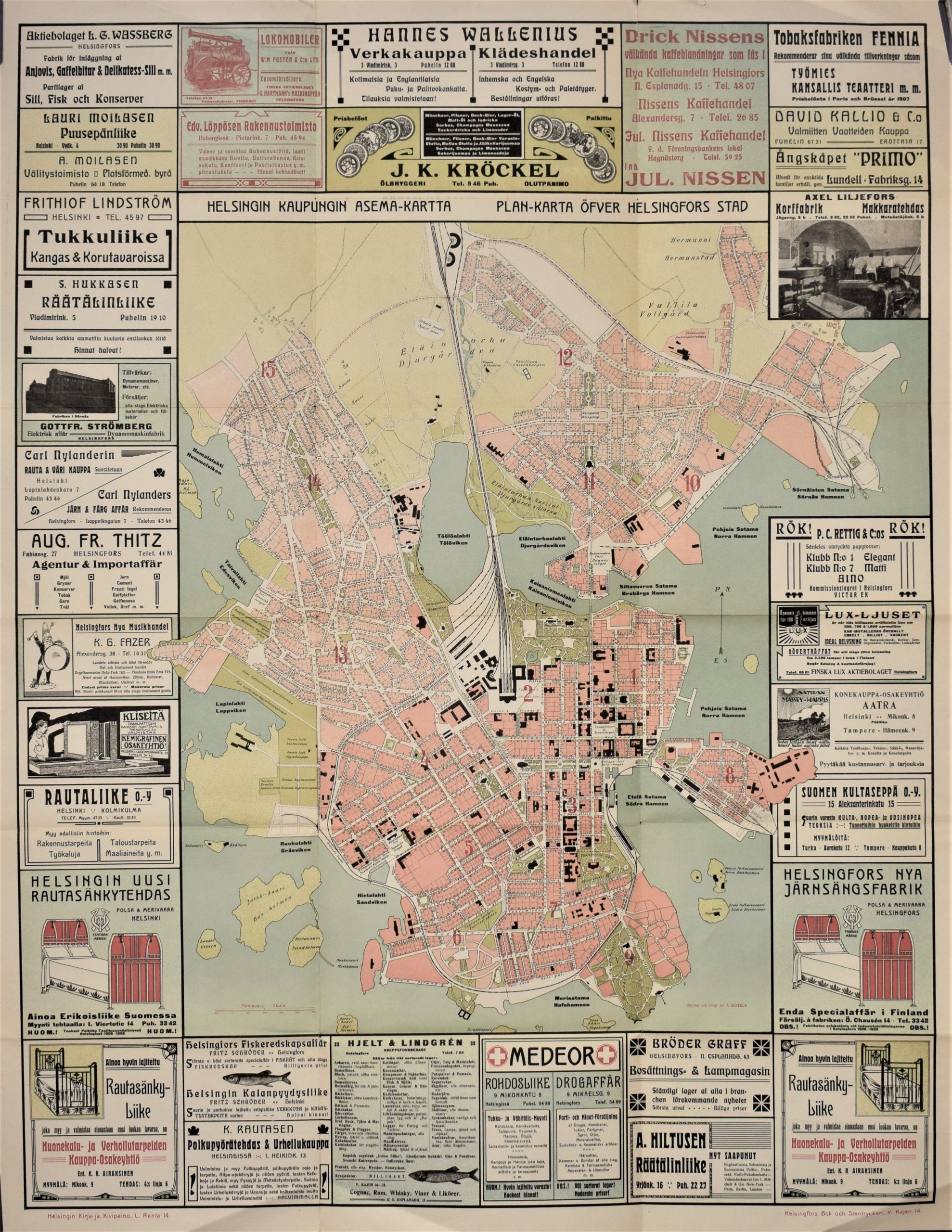
SCHEACK: Helsingin kaupungin asema-kartta (1910)
€900,00
A. Scheack
Helsingin kaupungin asema-kartta – Plan-karta öfver Helsingfors stad
Old map of Helsinki | Vanha Helsingin kartta | Gammal karta över Helsingfors
An interesting city plan of Helsinki from the early 20th century. A vibrant colour lithograph, printed by Helsingfors Bok- och Stentryckeri between 1906 and 1910.
This historical map has the fascinating border of advertisments from the era. These ads showcase iron beds, sausage factories and locomotives!
The map depicts the Helsinki peninsula, extending north to include Humallahti, Eläintarha, Vallila and Sörnäinen. The city districts and their respective blocks are numbered. Street names and notable places are presented in both Finnish and Swedish.
The map was originally folded, and the old fold lines remain vaguely visible. There is a small old stamp in the upper left corner. Otherwise, the map is in good condition.
- Condition: Good condition. Vaguely visible old fold lines.
- Dimensions: 95 x 74 cm
Suomeksi:
Vanha Helsingin kartta 1900-luvun ensimmäiseltä vuosikymmeneltä. Värikäs ja suurikokoinen kivipainokuva, jossa karttakuvaa kehystää mainosilmoitukset. Kaupunginosat numeroitu kartalle. Kadunnimet ja yleiset paikat nimetty sekä suomeksi että ruotsiksi. Kartta on ollut aikoinaan taiteltu, ja vanhat taitosjäljet ovat vielä jonkin verran näkyvissä.
Kunto: Hyvä kunto.
Mitat: 95 x 74 cm
På svenska:
Karta över Helsingfors stad från början av 1900-talet. Stort litografiskt tryck med färg. Intressant karta med mycket information. Reklamerna omger kartan. Stadsdelen är numrerade. Gatunamn på finska och svenska. Vikningar.
Skick: Gott skick. Vikningar.
Mått: 95 x 74 cm


