Shipping
Shipping is not included in the prices. The fee will be confirmed to the customer by a separate e-mail and depends on the parcel's size and destination.
Examples: Finland 5,90€; Sweden, Germany, Baltics 8,00€; Benelux, Denmark, Spain 12,00€; Non-EU 35,00€
terms & conditions
Before ordering we kindly ask you to read our terms and conditions.
availability
The selection of our online store is not available at the bookstore. If you wish to view some items, please contact us in advance.
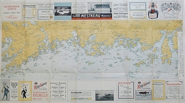
[20th century] Skärgårdskarta. Helsingfors – Porkala – Borgå (1912)
€480,00
Description
Skärgårdskarta. Helsingfors – Porkala – Borgå
Map of the Finnish archipelago between Porkkala, Helsinki and Porvoo. Interesting folded map from 1912 with advertisements of the time.
Dimensions 50,5 × 91,5 cm. Good condition.
Additional information
YEAR OF PUBLICATION:
1912
PLACE OF PUBLICATION:
Helsingfors
Condition:
3
Condition explanations:
(5) Mint, (4) Very good, (3) Good, (2) Fair, (1) Poor
Dimensions:
50,5x91,5
Other:
taitettu, vikt


